
This post contains outdated information.
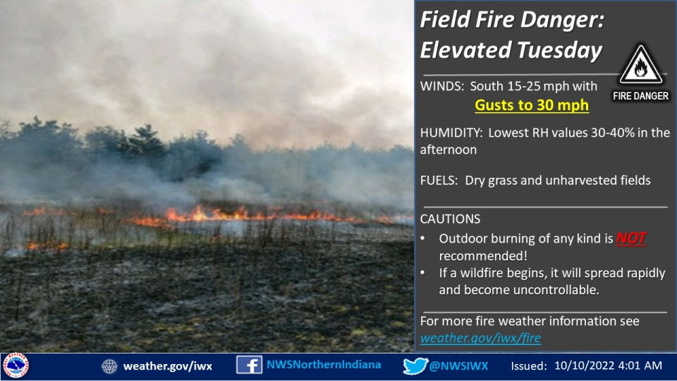
The National Weather Service has issued a Special Weather Statement warning of an elevated danger for field fires tomorrow, October 10, 2022.
Special Weather Statement
National Weather Service Northern Indiana
443 AM EDT Mon Oct 10 2022

INZ005>009-012>015-017-018-020-022>027-032>034-103-104-116-203-
204-216-MIZ078>081-177-277-OHZ001-002-004-005-015-016-024-025-
102300-
Elkhart-Lagrange-Steuben-Noble-De Kalb-Starke-Pulaski-Marshall-
Fulton IN-Whitley-Allen IN-White-Cass IN-Miami-Wabash-Huntington-
Wells-Adams-Grant-Blackford-Jay-Northern La Porte-
Eastern St. Joseph IN-Northern Kosciusko-Southern La Porte-
Western St. Joseph IN-Southern Kosciusko-Cass MI-St. Joseph MI-
Branch-Hillsdale-Northern Berrien-Southern Berrien-Williams-
Fulton OH-Defiance-Henry-Paulding-Putnam-Van Wert-Allen OH-
Including the cities of Elkhart, Goshen, Nappanee, Lagrange,
Topeka, Shipshewana, Angola, Fremont, Kendallville, Ligonier,
Albion, Auburn, Garrett, Knox, North Judson, Bass Lake, Winamac,
Francesville, Medaryville, Plymouth, Bremen, Culver, Rochester,
Akron, Columbia City, Tri-Lakes, South Whitley, Fort Wayne,
New Haven, Monticello, Monon, Brookston, Logansport,
Royal Center, Peru, Grissom AFB, Mexico, Wabash,
North Manchester, Huntington, Roanoke, Bluffton, Ossian, Decatur,
Berne, Marion, Gas City, Upland, Hartford City, Montpelier,
Portland, Dunkirk, Wanatah, La Crosse, Union Mills, South Bend,
Mishawaka, Lakeville, Granger, Syracuse, Milford, North Webster,
Leesburg, Michigan City, La Porte, Kingsbury, Fish Lake,
North Liberty, New Carlisle, Walkerton, Warsaw, Winona Lake,
Silver Lake, Mentone, Dowagiac, Cassopolis, Edwardsburg,
Marcellus, Sturgis, Three Rivers, White Pigeon, Mendon,
Coldwater, Bronson, Hillsdale, Jonesville, Litchfield,
Benton Harbor, St. Joseph, Paw Paw Lake, Niles, New Buffalo,
Stevensville, Berrien Springs, Bryan, Edgerton, Wauseon,
Archbold, Swanton, Delta, Defiance, Sherwood, Hicksville,
Napoleon, Deshler, Liberty Center, Paulding, Antwerp, Payne,
Ottawa, Leipsic, Columbus Grove, Continental, Pandora, Van Wert,
Ohio City, Lima, and Spencerville
443 AM EDT Mon Oct 10 2022 /343 AM CDT Mon Oct 10 2022/

...Elevated danger for field fires Tuesday...

An elevated risk for field fires will develop Tuesday with warm
weather and dry conditions prevailing. By Tuesday afternoon, south
winds will become breezy at 15 to 25 mph with gusts to 30 mph
greatly increasing the risk for spreading fires as minimum
relative humidity levels drop to between 30 and 40 percent.

Pronounced drying will continue with numerous fields becoming
very dry, increasing fire potential with any ignition. This fire
potential includes unharvested crop fields that have dried out as
well as areas of dry grass and dead brush.

Outdoor burning is not recommended. Any fires that are able to
start will likely spread rapidly and likely become out of control.
The latest National Weather Service weather story | Official National Weather Service Northern Indiana website