
This post contains outdated information.
The National Weather Service warns of a flooding threat overnight with a winter storm tomorrow.
View the latest Situation Report from the National Weather Service issued at 3:07 pm on February 16, 2022.
Tonight’s Fort Wayne, Indiana weather story from the National Weather Service:
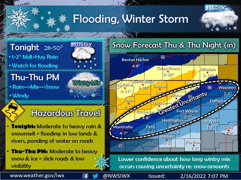
Fort Wayne, Indiana (February 16, 2022) -Quite a busy forecast the next couple of days, with spring (warm, wind, rain and flooding) tonight into early Thursday, then a transition back to winter (cold, snow, and ice) Thursday into Thursday night. Snow totals are depicted in the image to the right. The main thing to take away from this graphic is that travel will be hazardous tonight into probably Friday morning. Water is ponding on the roads already as of this post, and will only get worse as moderate to heavy rain develops overnight. If travelling, watch for water on the roads. If you live near a river or stream, monitor the latest river forecast for your area. Rain will transition to a wintry mix during the day on Thursday (from northwest to southeast), then eventually changeover to all snow. The snow will be moderate to heavy at times Thursday into Thursday night, with several locations seeing up to 6 to 11 inches of snow. There is lower confidence with respect to the exact transition time for the wintry mix (especially in the white circle on the snowfall map), and additional uncertainty about the exact track of the system. If the storm shifts further southeast, or the transition is quicker, then the axis of higher snow totals will also shift further southeast. If the transition is longer, we could see less snow and more ice. To see the exact forecast for your area, please visit our website and put in your zip code.
The latest National Weather Service weather story | Official National Weather Service Northern Indiana website
Related Images:
