
Last week’s rainfall and resulting flooding is finally for the most part over.
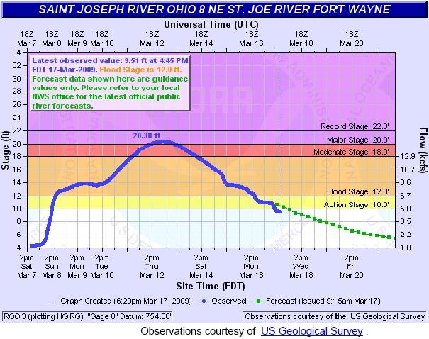
The St. Joseph River crested at 20.38 feet on March 13, 2009 around 4:30 pm. Â As far as the top ten list of historical crests, this is the second highest crest since March 26, 2009 when the level hit 22.0 feet. Â The top ten historical crests for the St. Joseph River:
- 22.00 ft on 03/26/1913
- 20.38 ft on 03/12/2009
- 17.90 ft on 04/07/1950
- 17.86 ft on 06/05/1989
- 17.79 ft on 02/26/1985
- 17.51 ft on 12/31/1990
- 17.37 ft on 02/07/2008
- 17.15 ft on 01/05/1993
- 16.70 ft on 05/18/1943
- 16.38 ft on 01/09/2008
I would also point out that there are now three dates/crests within the last year and a few months on the historical list. Â There were two crests during this flood. Â The first from the storms that swept through the entire region, both north and south of Fort Wayne. Â The second crest, the historical crest occured after the second batch of rainstorms which were concentrated mainly to the north of Fort Wayne.
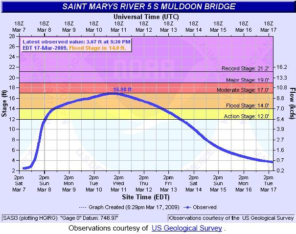
The St. Marys River crested at 16.98 feet around 11:15 am on March 11, 2009. Keep in mind that the gauge for this at the Muldoon Bridge which is quite a distance down the river from Headwaters Park. Â I’ve been asked why Headwaters and the downtown area flooded so badly when compared to other years with similar levels. Â The biggest reason is with all the water coming down the St. Joseph River from the second wave of rainstorms, the water had nowhere to go. Â It all backed up into Headwaters Park – which is exactly the purpose the park was created for.
The top 10 historical crests for the St. Marys River:
- 21.20 ft on 07/09/2003
- 19.66 ft on 03/14/1982
- 19.06 ft on 01/14/2005
- 18.33 ft on 02/26/1985
- 17.92 ft on 01/01/1991
- 17.67 ft on 02/09/2008
- 17.07 ft on 07/18/1992
- 17.03 ft on 01/26/1999
- 16.98 ft on 03/11/2009
- 16.06 ft on 02/13/2009
This time, there are five historical crests since the turn of the century, with the rest occurring in the 1980s and 1990s.
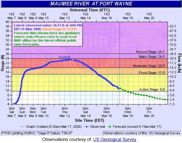
The Maumee River crested at 23.58 feet on March 13, 2009 at 7:15 am. Â The pattern here echoed that of the St. Joseph River, which is logical given that both the St. Joseph and St. Marys Rivers both drain into the Maumee. Â The historical crests for the Maumee:
- 26.10 ft on 03/26/1913
- 25.93 ft on 03/17/1982
- 24.55 ft on 02/27/1985
- 23.90 ft on 01/01/1991
- 23.76 ft on 03/24/1978
- 23.58 ft on 03/13/2009
- 22.93 ft on 02/08/2008
- 22.50 ft on 03/08/1908
- 22.44 ft on 01/14/2005
- 22.40 ft on 01/15/1930
This was the 6th highest crest for the Maumee River. Â There have only been three historical crests for the Maumee since the turn of the century. Â Unlike the other two however, the rest of the Maumee’s crest are spread out with three in the 1908-1930 period and the rest between 1978 and 1991.
Please note: The information used to compile the above post is from the National Oceanic and Atmospheric Administration’s National Weather Service section of the website. Â If you are interested, each individual river’s level monitors have a rss or xml feed which you may subscribe to. Â This will allow you to receive periodic updtes when flood waters threaten. Â Each river may be reached from this page.
Related Images:


