
This post contains outdated information.
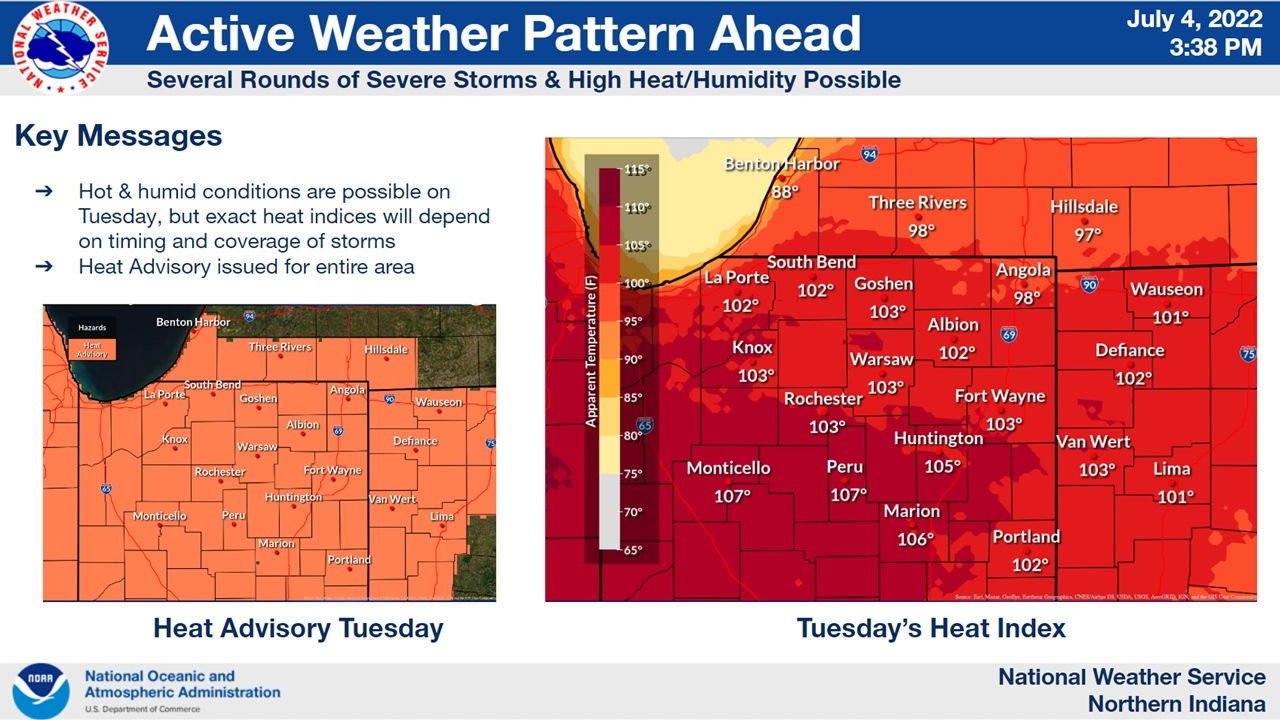
The National Weather Service has issued a Heat Advisory for tomorrow, in effect tonight, July 5, 2022, at 10:00 pm.
URGENT - WEATHER MESSAGE
National Weather Service Northern Indiana
308 PM EDT Mon Jul 4 2022

INZ003>009-012>018-020-022>027-032>034-MIZ077>080-OHZ001-002-004-
005-015-016-024-025-050315-
/O.NEW.KIWX.HT.Y.0004.220705T1700Z-220706T0200Z/
La Porte-St. Joseph IN-Elkhart-Lagrange-Steuben-Noble-De Kalb-
Starke-Pulaski-Marshall-Fulton IN-Kosciusko-Whitley-Allen IN-
White-Cass IN-Miami-Wabash-Huntington-Wells-Adams-Grant-Blackford-
Jay-Berrien-Cass MI-St. Joseph MI-Branch-Williams-Fulton OH-
Defiance-Henry-Paulding-Putnam-Van Wert-Allen OH-
Including the cities of Michigan City, La Porte, South Bend,
Mishawaka, New Carlisle, Walkerton, Elkhart, Goshen, Nappanee,
Lagrange, Topeka, Shipshewana, Angola, Fremont, Kendallville,
Ligonier, Albion, Auburn, Garrett, Knox, North Judson, Bass Lake,
Winamac, Francesville, Medaryville, Plymouth, Bremen, Culver,
Rochester, Akron, Warsaw, Winona Lake, Syracuse, Mentone,
Columbia City, Tri-Lakes, South Whitley, Fort Wayne, New Haven,
Monticello, Monon, Brookston, Logansport, Royal Center, Peru,
Grissom AFB, Mexico, Wabash, North Manchester, Huntington,
Roanoke, Bluffton, Ossian, Decatur, Berne, Marion, Gas City,
Upland, Hartford City, Montpelier, Portland, Dunkirk, Niles,
Benton Harbor, St. Joseph, Fair Plain, Benton Heights, Buchanan,
Paw Paw Lake, Dowagiac, Cassopolis, Edwardsburg, Marcellus,
Sturgis, Three Rivers, White Pigeon, Mendon, Coldwater, Bronson,
Bryan, Edgerton, Wauseon, Archbold, Swanton, Delta, Defiance,
Sherwood, Hicksville, Napoleon, Deshler, Liberty Center,
Paulding, Antwerp, Payne, Ottawa, Leipsic, Columbus Grove,
Continental, Pandora, Van Wert, Ohio City, Lima, and Spencerville
308 PM EDT Mon Jul 4 2022 /208 PM CDT Mon Jul 4 2022/

...HEAT ADVISORY IN EFFECT FROM 1 PM EDT /NOON CDT/ TO 10 PM EDT
/9 PM CDT/ TUESDAY...

* WHAT...Heat index values over 100 expected.

* WHERE...Portions of northern Indiana, southwest Michigan and
  northwest Ohio.

* WHEN...From 1 PM EDT /noon CDT/ to 10 PM EDT /9 PM CDT/
  Tuesday.

* IMPACTS...Hot temperatures and high humidity may cause heat
  illnesses to occur.

* ADDITIONAL DETAILS...These forecast heat index values will be
  contingent on early Tuesday convection and any resulting cloud
  debris moving out and staying out of the area during the day to
  allow for maximum sunshine.

PRECAUTIONARY/PREPAREDNESS ACTIONS...

Drink plenty of fluids, stay in an air-conditioned room, stay out
of the sun, and check up on relatives and neighbors. Young
children and pets should never be left unattended in vehicles
under any circumstances.

Take extra precautions if you work or spend time outside. When
possible reschedule strenuous activities to early morning or
evening. Know the signs and symptoms of heat exhaustion and heat
stroke. Wear lightweight and loose fitting clothing when
possible. To reduce risk during outdoor work, the Occupational
Safety and Health Administration recommends scheduling frequent
rest breaks in shaded or air conditioned environments. Anyone
overcome by heat should be moved to a cool and shaded location.
Heat stroke is an emergency! Call 9 1 1.
Related posts:
- Weather Story: Active weather ahead
- NWS: Severe storms possible tonight
- NWS Update: Heat Advisory until 10 pm tonight – 7/5/2022
- NWS Situation Report issued July 5, 2022 at 3:48 pm
- NWS: Heat Exhaustion vs. Heat Stroke
- NWS: Tips for dealing with the heat and humidity
- National Weather Service Northern Indiana official website
Related Images:
