
This post contains outdated information.
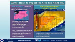
Potential winter storm snowfall totals for round 1 of the upcoming storms from the National Weather Service:
Tonight’s Fort Wayne, Indiana weather story from the National Weather Service:
Potential winter storm snowfall totals, round 1
Fort Wayne, Indiana (January 31, 2022) – A winter storm will impact the area beginning late Tuesday night and continue into Thursday. This storm will impact the area in two phases. The first period of moderate to heavy snow is expected from late Tuesday night into Wednesday night as a frontal boundary changes rain to snow. A lull in snow intensity is possible for Wednesday evening, but another round of heavy snow is then expected on Thursday. The combination of heavy snow accumulations and gusty north to northeast winds to 25 to 35 mph will create very dangerous travel conditions, especially on Thursday due to reduced visibilities. In addition, some sleet and freezing rain cannot be ruled out during this period, especially along and south of the US Route 24 corridor.
View the snowfall totals for round 2.
Download the National Weather Service Situation Report as of January 31, 2022, at 2:53 pm.
View the Winter Storm Warning and Watch from the National Weather Service.
The latest National Weather Service weather story | Official National Weather Service Northern Indiana website
Related Images:
