
This post contains outdated information.
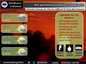
The National Weather Service reports that our stagnant weather pattern will continue with hot, humidity, showers, and thunderstorms into the weekend.
Hot and humid conditions hanging on
Periodic chances for storms, difficult to time best chancesFort Wayne, Indiana (August 26, 2021) – Stagnant pattern continues with hot and humid conditions along with chances for showers and thunderstorms into the weekend. While the heat and humidity will give fuel for the storms, features to help them develop will prove difficult to pin down with regards to best timing or coverage. If you end up with a storm, be prepared for lots of lightning and torrential rainfall, possibly well over an inch per hour. Ponding of water and isolated flooding will be possible. Outside of any storms, heat indices each afternoon will range from 95 to 100, with the potential to exceed 100 in a few areas, especially those that see full sunshine. Stay cool and hydrated!
The latest National Weather Service weather story | Official National Weather Service Northern Indiana website
Related Images:
