
This post contains outdated information.
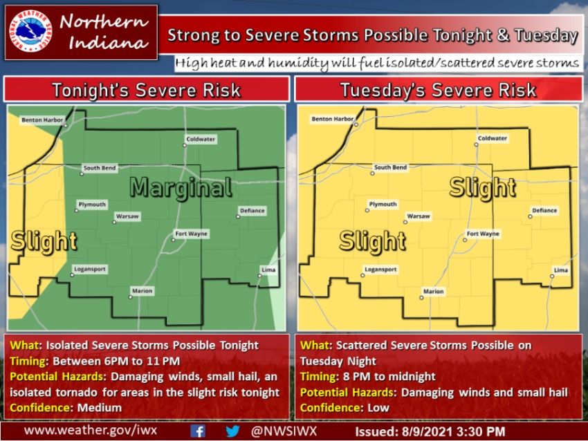
The National Weather Service is forecasting the possibility of strong to severe storms this evening into the overnight hours between 6 PM to 11 PM.
Download the latest NWS Situation Report concerning the severe weather threat.
Strong to severe storms possible tonight and Tuesday
High heat and humidity will fuel isolated/scattered severe stormsFort Wayne, Indiana (August 9, 2021) – Strong to severe storms are possible this evening into the overnight hours between 6 PM to 11 PM. A majority of our warning area is in a Marginal Risk (level 1 out of 5), with areas off to the far west in a Slight Risk (level 2 out of 5). The main threats are damaging wind gusts and small hail, however, an isolated tornado cannot be ruled out for areas in the Slight Risk in northwest Indiana. Confidence in severe weather occurring tonight is medium. Tomorrow, high heat and humidity will fuel another possibility for severe weather. Our entire warning area, as well as much of the Great Lakes Region, is in a Slight Risk (level 2 out of 5). High temperatures tomorrow will be in the lower 90s, with heat indices peaking at 100-105 degrees. Scattered strong to severe storms are possible after sunset tomorrow night from 8 PM to midnight, with the greatest threats, if severe weather materializes, being damaging winds and small hail. Confidence in tomorrow’s severe weather is low. Stay weather aware tonight and tomorrow night!
The latest National Weather Service weather story | Official National Weather Service Northern Indiana website
Related Images:
