
This post contains outdated information.
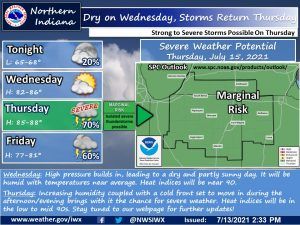
The National Weather Service is forecasting that the scattered showers and storms will taper off this afternoon, leading to dry conditions tonight into the day tomorrow.
Dry tomorrow, rain/storms to end the week
Fort Wayne, Indiana (July 13, 2021) – Scattered showers and storms taper off this afternoon, leading to dry conditions tonight into the day tomorrow. Expect low temperatures tonight in the mid to upper 60s. Wednesday features temperatures near average in the low to mid 80s, with increasing humidity. Heat indices will be near 90. On Thursday, temperatures will be in the mid to upper 80s, with heat index values in the low to mid 90s. A cold front will move into northern Indiana and southwestern Michigan on Thursday afternoon, which brings the chances for severe weather. At this time, the Storm Prediction Center has our entire forecast area in a Marginal (level 1/5) risk for severe weather. Monitor our forecast for future updates in the coming days.
The latest National Weather Service weather story | Official National Weather Service Northern Indiana website
Related Images:
