
This post contains outdated information.
- NWS: Freeze Warning tonight – 20th April 2021 @ 03:30
- NWS: Winter Weather Advisory issued – 20th April 2021 @ 03:49
- NWS Weather Story: Snow today and tonight; freezing temps overnight – 20th April 2021 @ 06:00
- Situation Report from the National Weather Service – 20th April 2021 @ 03:50
- The official National Weather Service Northern Indiana website
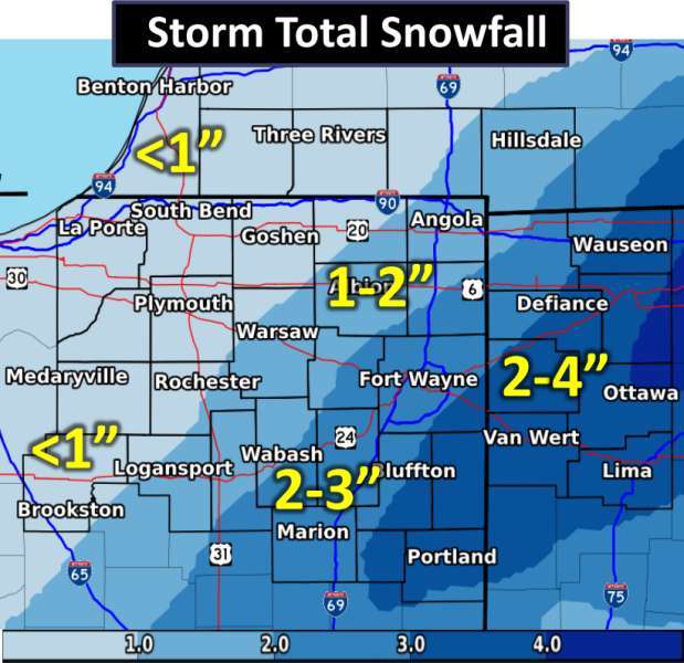
The National Weather Service has issued a Winter Weather Advisory that is in effect from April 20, 2021, 07:00 PM EDT, until April 21, 2021, 07:00 AM EDT.
URGENT – WINTER WEATHER MESSAGE
National Weather Service Northern Indiana
349 AM EDT Tue Apr 20 2021INZ007>009-017-018-024>027-032>034-MIZ081-OHZ001-002-004-005-015-016-024-025-201600-/O.NEW.KIWX.WW.Y.0010.210420T2300Z-210421T1100Z/
Steuben-Noble-De Kalb-Whitley-Allen IN-Wabash-Huntington-Wells-Adams-Grant-Blackford-Jay-Hillsdale-Williams-Fulton OH-Defiance-Henry-Paulding-Putnam-Van Wert-Allen OH-
Including the cities of Angola, Fremont, Kendallville, Ligonier, Albion, Auburn, Garrett, Columbia City, Tri-Lakes, South Whitley, Fort Wayne, New Haven, Wabash, North Manchester, Huntington, Roanoke, Bluffton, Ossian, Decatur, Berne, Marion, Gas City, Upland, Hartford City, Montpelier, Portland, Dunkirk, Hillsdale, Jonesville, Litchfield, Bryan, Edgerton, Wauseon, Archbold, Swanton, Delta, Defiance, Sherwood, Hicksville, Napoleon, Deshler, Liberty Center, Paulding, Antwerp, Payne, Ottawa, Leipsic, Columbus Grove, Continental, Pandora, Van Wert, Ohio City, Lima, and Spencerville
349 AM EDT Tue Apr 20 2021…WINTER WEATHER ADVISORY IN EFFECT FROM 7 PM THIS EVENING TO 7 AM EDT WEDNESDAY…
* WHAT…Snow expected. Total snow accumulations of 2 to 5 inches.
* WHERE…Portions of northern Indiana, southwest Michigan and northwest Ohio.
* WHEN…From 7 PM this evening to 7 AM EDT Wednesday.
* IMPACTS…Roads are likely to become slippery overnight as temperatures fall below freezing. These hazardous conditions will likely impact the morning commute.
PRECAUTIONARY/PREPAREDNESS ACTIONS…
Related Images:
