
Today’s Fort Wayne, Indiana weather story from the National Weather Service is forecasting light snow this morning and early afternoon before the heavier snowfall occurs:
This post contains outdated information.
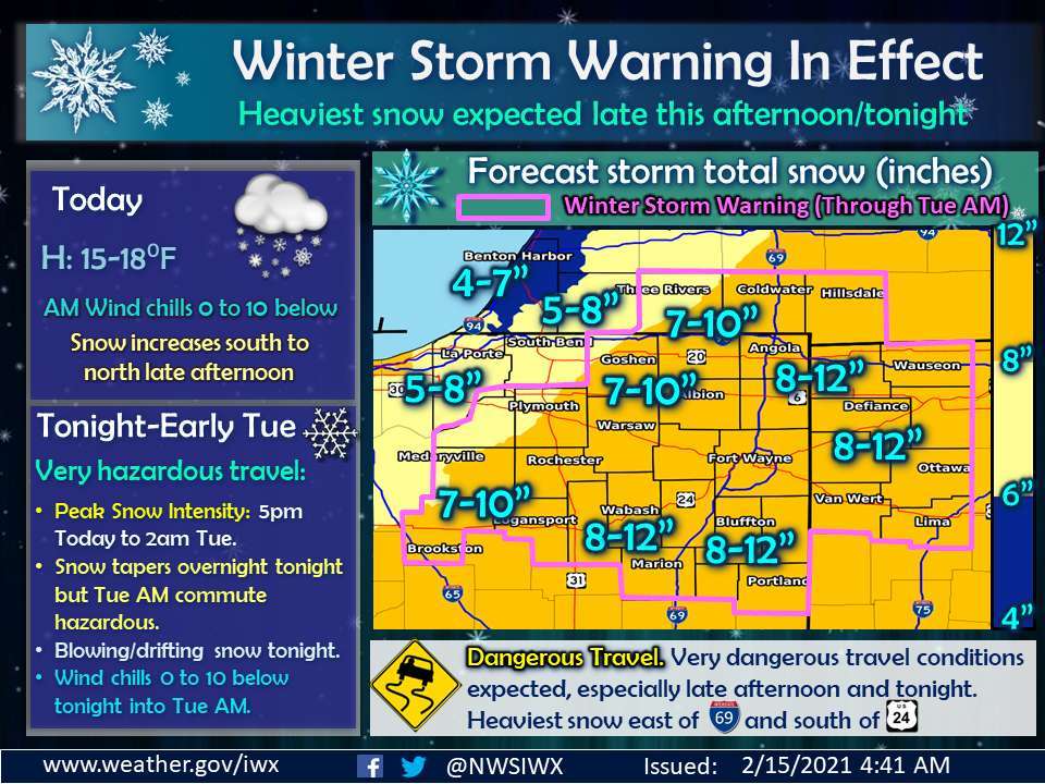
Winter Storm Warning in Effect
Heaviest snow expected late this afternoon/tonight
Fort Wayne, Indiana (February 15, 2021) – Light snow will continue this morning, but a lull in the more widespread light snow is expected to develop later this morning into early this afternoon.
An area of heavy snow is then expected to lift northward across the region late this afternoon into tonight. Snowfall rates of 1 to 2 inches per hour will be possible this evening. Storm total snow accumulations of 6 to 12 inches are expected in the winter storm warning area with the highest amounts generally east of Interstate 69 and south of US Route 24.
In addition, some blowing and drifting snow will develop tonight as north winds strengthen to 15 to 20 mph with some gusts to 25 mph. Winter Storm Warnings remain in effect for the area highlighted in pink, through Tuesday morning with Winter Weather Advisories across northwest Indiana into southwest Lower Michigan. Snow will taper off overnight tonight, but the Tuesday morning commute will likely be very hazardous due to snow covered roads.
Looking ahead, another system may bring some significant snowfall to the region by late Wednesday into Thursday. Stay updated on the latest forecasts this week at http://www.weather.gov/iwx.
Related information:
- NWS update: Winter Storm Warning
- NWS: Light snow before the heavier snowfall
- NWS: Situation Report at 6:47 am
- Community Harvest closed tomorrow – 2/15/2021
- City preparing streets for more snow event
- Garbage collection will slow this week
- INDOT prepared for Major Winter Storm
- City: Pipes and water meters can freeze
- Official National Weather Service Northern Indiana website
Related Images:
