
A significant, early season winter storm moved through the entire forecast area on November 29, 2025, into early November 30, 2025.
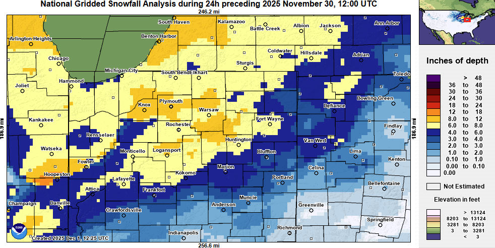
From the National Weather Service:
A significant, early season winter storm moved through the entire forecast area on November 29th into early November 30th. Moderate to heavy snow was occurring by the afternoon and evening of November 29th, with visibilities between a 1/2 and 1/4 of a mile reported through much of the day into the evening. Blowing and drifting snow were reported, with road conditions becoming treacherous. Widespread snow totals of 6-10” (isolated higher up to 12”) were reported by 11 pm ET the 29th, with areas further southeast reporting closer to 2-6″. Between 12 AM and 2 AM EST November 30th, precipitation in some areas transitioned from all snow to a wintry mix of sleet/freezing drizzle/snow and even all rain in some locations as temperatures briefly rose to right at or slightly above freezing. Widespread system snow was done early morning on the 30th, then lake effect developed downwind of Lake Michigan and moved inland for areas mainly west of I 69 and along/north of US 30 into the evening hours.
The 5.6 inches of snow that fell at Fort Wayne on November 29th was the third highest daily snowfall total for the month of November on record. The highest daily totals were 6.2 inches and 6.0 inches in 1942 and 1950. The 9,0 inches of snow that fell at South Bend on November 29th was the eighth highest daily snowfall total for the month of the November. The highest daily snowfall total at South Bend for November was 18.0 inches in 1911.
Related Images:
