
The National Weather Service has issued a Wind Advisory in effect from March 15, 12:00 AM EDT until March 15, 8:00 PM EDT.
from the National Weather Service:
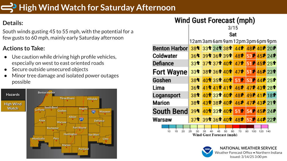
URGENT - WEATHER MESSAGE
National Weather Service Northern Indiana
934 PM EDT Fri Mar 14 2025

INZ005>009-012>015-017-018-020-022>027-032>034-103-104-116-203-204-
216-MIZ078>081-177-277-OHZ001-002-004-005-015-016-024-025-151345-
/O.UPG.KIWX.HW.A.0001.250315T1600Z-250315T2200Z/
/O.NEW.KIWX.WI.Y.0003.250315T0400Z-250316T0000Z/
Elkhart-Lagrange-Steuben-Noble-De Kalb-Starke-Pulaski-Marshall-
Fulton IN-Whitley-Allen IN-White-Cass IN-Miami-Wabash-Huntington-
Wells-Adams-Grant-Blackford-Jay-Northern La Porte-Eastern St.
Joseph IN-Northern Kosciusko-Southern La Porte-Western St. Joseph
IN-Southern Kosciusko-Cass MI-St. Joseph MI-Branch-Hillsdale-
Northern Berrien-Southern Berrien-Williams-Fulton OH-Defiance-
Henry-Paulding-Putnam-Van Wert-Allen OH-
934 PM EDT Fri Mar 14 2025 /834 PM CDT Fri Mar 14 2025/

...WIND ADVISORY IN EFFECT UNTIL 8 PM EDT /7 PM CDT/ SATURDAY...

* WHAT...South winds 20 to 30 mph tonight into Saturday evening.
  Gusts up to 45 mph expected tonight, and up to 55 mph by Saturday
  afternoon. A few gusts up to 60 mph are possible Saturday
  afternoon.

* WHERE...Portions of northern Indiana, southwest Michigan, and
  northwest Ohio.

* WHEN...Until 8 PM EDT /7 PM CDT/ Saturday.

* IMPACTS...Gusty winds will blow around unsecured objects. Tree
  limbs could be blown down and a few power outages may result.

* ADDITIONAL DETAILS...A line of showers and thunderstorms is
  expected tonight into Saturday morning that could bring higher
  wind gusts.

PRECAUTIONARY/PREPAREDNESS ACTIONS...

Winds this strong can make driving difficult, especially for high
profile vehicles. Use extra caution.

Secure outdoor objects.

&&

$$

MCD
Download the latest NWS Situation Report.
The latest National Weather Service weather story | Official National Weather Service Northern Indiana website
Related Images:
