
There are several articles on the JG’s website that deals with the Fairmount Place land and controversy. Â Tracy Warner does a nice job of laying out the timeline. Â As I mentioned, this is a big part that until today had not been discussed publicly of the frustration experienced by neighbors and business owners in the area. Â Some excerpts from the articles:
A Flood of MISSTEPS
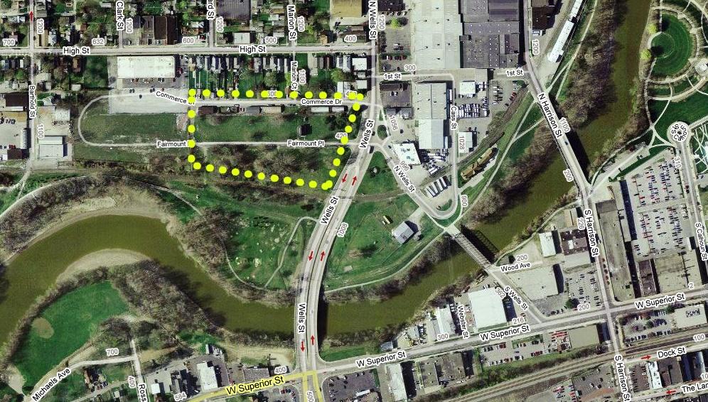
City sells flood-control land for a song; women’s shelter doesn’t benefit
Tracy Warner | Editorial Page EditorÂ[…] The city spent $350,000 in 1984 to buy 17 homes along Fairmount Place, off Wells Street, and demolish them. In 2002, the city sold that property – for $8,800.
Five years later, the man who bought the land – zoned for industrial use – resold it to the operators of the Rescue Mission and Charis House to build a new homeless shelter.
Sale price: $525,000.
This is the story of how a bureaucratic snafu rippled across 3 1/2 acres of land just north of the St. Marys River, leaving only Dyle Hughes smiling.
[…] As part of the project, the city needed to hook up electricity to pumps and a sluice gate, which allows water to flow from a pipe into the river but not back into the pipe.
[…] City officials “thought they owned the property,” Hughes said. “But they didn’t.”
Some of the flood-control apparatus that needed electrical access, it turns out, was on the wrong side of the boundary that separated city-owned land with property Hughes owned. He had bought it a few years earlier at a public auction of unwanted railroad property.
Hughes was told that the project installed through his property was worth $1.5 million.
That gave him negotiating leverage.
[…] City officials last week said they were unclear about the chronology of events. “It’s still not crystal clear because so many of the people who were involved with it are no longer” with the city, said John Urbahns, director of community development. And to be fair, city officials most involved with flood-control efforts were pretty busy last week fighting a flood.
[…] Had city and Army Corps of Engineers officials known beforehand the land was privately held, they likely could have bought it as part of their massive $44.7 million budget. But with the project nearly concluded, the city ended up selling to Hughes – for a song – the lots it bought on both sides of Fairmount in 1984 as part of its flood-fighting efforts.
City officials were unable to locate the details of the purchase prices last week. Hughes declined to say how much he paid.
But records in the Wayne Township assessor’s office indicate Hughes paid the city $8,800.
[…] The property had been for sale for about $700,000, said Tuck Hopkins, chairman of the mission ministries group. Ministry officials were pleased to get it for $525,000.
Collectively, though, the lots were assessed for tax purposes at just $72,500.
That is not as bad as it seems. Each lot is assessed individually; all the lots together are more valuable than the sum of the parts. And, as any real estate professional will tell you, the value of any property is what a buyer will pay.
[…] For many years, social-service officials had been concerned the city offered no equivalent temporary shelter for homeless women and children. Fort Wayne Rescue Mission Ministries, the umbrella group that runs the mission, set about to change that. It raised $400,000-plus to buy and renovate a downtown West Washington Boulevard house that opened as Charis House in 1996.
[…] The current location offers a maximum of 42 beds, but the exact number can be lower, depending on the configuration of how many children each woman there has. Business, sadly, is booming. Charis House – which has to turn down about 300 women a year – needs more room.
(Webmaster’s Note: 300 women a year?  In an op-ed piece written for the Journal Gazette in early March, Tuck Thompson stated 250 women.  Both of these figures contradict the Charis House’s own chart they gave me in February – by quite  a large number.  For more on this read this post.  No one doubts the validity of the need for this in our community, however, let’s be consistent and veracious in those statements. To be fair to the Charis House, the difference between 250 and 300 may lie with the newspaper staff.)
[…] Whether or not the property was worth what the mission paid, it has value to the new owners only if the new Charis House can be built there.
“We checked with the city. The city said it was zoned for it,” Hopkins said. “It’s properly zoned for what we want to do.”
[…] But given the land’s industrial designation, other interpretations are possible.
A professional developer would likely have received a separate legal opinion and made the sale contingent on receiving all necessary zoning approvals and permits. But mission ministries bought it, lock, stock, barrel and industrial zoning tag.
[…] Perhaps the most frustrating element of this story is the fact the city practically gave away 3 1/2 acres of land it bought for flood protection – and the decision was completely under the radar of the public.
Who made the decision to sell? Graham Richard, mayor when the properties changed hands in 2002, doesn’t remember it. Don Schmidt, Tom Smith and Tim Pape – all City Council members of the time – knew nothing about it until the recent news coverage of the Charis House plans.
Urbahns said city officials could not locate paperwork regarding the sale.
[…] Had it kept the property, the city could have expanded Guildin Park to the north, linked by the Rivergreenway to nearby Headwaters Park.
[…] If there is no zoning challenge, Charis House will likely build some version of its shelter and help a lot of homeless women and children. Wells Street business owners who wanted retail on the property will have some input into how the shelter looks.
But if neighbors decide to challenge the zoning issue – and they appear to have a case – that could set off lengthy litigation challenging the assurance the city-county planners gave that a homeless shelter could be built on the industrial land.
[…] But in the end, no one will win unequivocally – except for Dyle Hughes.
This article on the web.
Second article:
Will it flood near Wells?
by Tracy Warner
[…] Last week, much of the property where original plans called for the new Charis House to be built was underwater.(Webmaster’s note: I do think describing the flooding of that property last weeks as “much” is a bit of overstatement. Â I was down there Wednesday afternoon, which is about the time the St. Mary’s River had begun to recede. Â The water that was on the property would possibly have come to the shelter’s back door, but I think even that would have been a stretch. Â True, I wasn’t there at it’s worse, but I hardly think what I saw was far off the mark. Â I would have estimated about 20-25% of the property to have been underwater when I saw it.)
The property remains in a 500-year flood area – which means that in any given year, it has a two-tenths of 1 percent chance of flooding. But much of the city is in such an area.
“We wouldn’t really advocate any type of construction” there, said Rod Renkenberger, director of the Maumee River Basin Commission.
“It’s still in a flood risk area.”
Third Article:
Does zoning permit shelter?
By Tracy Warner[…] The city’s zoning ordinance, in fact, explicitly states that “New residential uses are not permitted in (industrial) zoning districts.”
[…] The proposed location is zoned general industrial. The way the zoning law is worded, property with that designation may have uses permitted in the less-restrictive commercial zoning, which allows a group home.
Kim Bowman, city-county planning director, is confident a homeless shelter can be built on land zoned for industry. But if the issue ever went to court, a judge could determine that the zoning law was indeed intended to prohibit new residential buildings in land zoned for industry.
And from the Editorial staff:
The city spent $350,000 in 1984 to buy and raze homes on the property it sold 18 years later for just $8,800. In 2007, the new owner resold that same property for $525,000.
Compounding the questionable decision-making: The worthy non-profit agency that bought the land did so without conditions and could well face a zoning challenge over its plans to build a homeless shelter on land zoned for industry.
[…]Â Had the city kept the property – along Fairmount Place, just off Wells Street – it could have expanded Guildin Park to the north, linked by the Rivergreenway to nearby Headwaters Park.
Or, as some council members now suggest, the property had potential for a flood-control friendly riverside attraction.
[…] City code requires council approval of city land purchases but not sales. In light of the Fairmount Place sale, when city officials appeared to ignore the best interests of their constituents and did not present the matter for any kind of public review, the council should require the administration to receive council approval of land sales as well.
The issue also has spotlighted a conflict in the city zoning code, which seems to both permit and prohibit a group home from being built on the industrial-zoned property. Planners should clarify the law.
Fort Wayne Rescue Mission Ministries has a worthy plan to build a needed home for homeless women and children. But it may well have erred in not making the purchase contingent on final approval of all planning and zoning agencies and after any legal challenges. Questions about zoning could delay or disrupt the project.
In the end, the city should have never lost control of the Fairmount Place lots. Had this issue been aired publicly, council members would have surely raised the same concerns they are raising now, only then they could have done a lot more about it.
As it stands, Fairmount Place is – and might always be – a road to nowhere.
Lessons learned
No. 1: Government officials ought not to be building expensive infrastructure projects on property until they absolutely, positively know that they own it – and only then after they double-check that.No. 2: Members of non-profit boards should heavily scrutinize purchases – particularly those in the six-figure range – and get their own experts to check complex issues like land use before putting the money down.
No. 3: Perhaps the most important lesson: Key governmental decisions – like practically giving away 3½ acres of downtown real estate – should be made in public.
Related Images:


Stephen:
In the records I researched, different zoning designations were attached to the lots: condominium (residential), commercial vacant, and residential vacant.
Most of the 28 lots held by Hughes were designated residential vacant. I am fairly confused at this point as to just how and why this entire transaction happened.
I am going to do some more research, and I hope to have an article posted yet tonight.
Hi Charlotte,
Thank you for your comments! Please let me know when you have your article posted as I will certainly link and highlight it here. I also have some thoughts about your comments which I will post later tonight or tomorrow. I want to try to get out this afternoon to shoot some photographs on this beautiful day!
Thank you so much!
Stephen,
My numbers cleared the 200 mark but only scratched the possibility of 250. There is no way they can hit 300 at any given pointe without an additional expansion. I relied very heavily on your coverage and analysis for my own commentary and suggestions. I wanted to leave this as a personal note of gratitude for your reporting on these issues. I will incorporate this new information as soon as I get back from a board meeting and taking a look at the properties in question as Fairmount Place is directly across the street from where our Board meets weekly, etc. Again Thank you for your detailed analysis and coverage of these issues.
Blessings and Peace,
+Kenneth
Stephen,
Your pictures of the groundwater on Fairmount Place are the best I have seen.Can this property be developed? My answer is yes. But to develop it by merely filling in to raise the ground level will certainly push that water north to Commerce and to the back of High St. properties as well west to the property that would become landlocked if the street was vacated.What should happen here is to have the first floor for parking with development above. Personally , I would love to see some shops and some restaurants on the second floor with balconies for outside dining that overlook the St. Mary’s River and downtown. What an awesome view! I am pursuing having some sketches made for what “should” be on this site for the citizens of Fort Wayne and the overall good of the community.
Hi Kenneth,
The problem is with the graph they gave me. This graph never even breaks the 100 mark for women or children in any given year. Now all of a sudden, the number they’re turning away is 250+? That’s part of the problem I have with this.
I know there is a need, however, to quantify that need seems to be a problem. The other thing to remember, when we’re talking about the homeless, is that every December, a homeless count is conducted. They turn up very few if any actual homeless persons living on the streets. The numbers for those homeless, I can’t remember the term, that are staying with someone so they’re not technically homeless, is substantial, but still. What is the real need here?
Now, all that said, the Charis House is in need of a new shelter. The current facility was never meant to be a homeless shelter and needs constant repairs and updating. I can totally understand the desire to be in a more comfortable residence.
Stephen
Thank you, Judi!
I have copies of the sketches City Councilman Tom Smith had drawn up years ago for riverfront development where Old Fort Wayne is as well as around Lawton Park and OmniSource. I’ve been meaning to post them as well as some comments from an interview I did with the Councilman concerning his thoughts. Perhaps now is the time. If I can ever get caught up, I’ll do this.
Stephen
Stephen:
I pulled this over from one of your other posts for the discussion about the Indiana statute and city code sections included. We cannot ignore the statute ad the city code. So bear with re-reading the post since it is the same as the one at your other article.
_________________________________________________________________
I am amazed – actually more like appalled – that all these lots could simply be sold to a private individual – especially when the City paid for these with taxpayer dollars (according to the article) to demolish the homes and remove them from the flood plain.
The transfers are a convoluted mess. Public records show that 28 lots on Fairmount Place were in the name of Dyle Hughes before he sold to Rescue Ministries. The owner of record who held them prior to the sale was Housing and Neighborhood. I am curious as to what kind of sale was held to allow Hughes to purchase property in a flood plain.
What I am having trouble understanding from the article is the flood control project that required access to the St. Marys to hook up a pipe began in 1994 yet Hughes’ purchase of the Fairmount properties didn’t occur until August 2002 – again according to the paper and the public records I searched. In reading the article, I thought that only a small area was needed to allow the Corps’ project to be completed.
How did Hughes end up with virtually every lot in the area?
One lot was even held by Jean Markey as a trustee at one point.
So the City used taxpayer funds (according to the article) to buy out the property owners for purposes of flood mitigation, and Dyle Hughes bought them for a pittance and then made a killing at $525,000.
Our homes here at the intersection of Nelson, Thieme Drive, and West Berry are built up high enough that the water does not approach the first floor. I get just a little water in my basement, but that is from river water flowing through the soil – which is fill dirt in this area. Yet, I also know that the homes in this small area are targeted for a voluntary buyout – or at least they were.
While my experience is annoying and nerve-wracking, I understand that if buildings are built high enough the water won’t enter into the living areas of our homes.
But since this a good reminder that the Fairmount Place area does flood, how would riverfront development even be allowed to occur? Our state has statutes that require development within 1500 feet of the river itself unless the area lies in a flood plain and then the distance increases to the point where the river may not even be within view.
The following is the statute that addresses riverfront development of restaurants, clubs, and hotels developed near a river front and anticipating service of alcohol. Since most of the talk of river front development revolves around eateries, I believe this statute would apply.
_______________________________________________________________________________
7.1-3-20-16.1. Municipal riverfront development project — Permit criteria — Proof of compliance.
(a) This section applies to a municipal riverfront development project authorized under section 16(d) [IC 7.1-3-20-16(d)] of this chapter.
(b) In order to qualify for a permit, an applicant must demonstrate that the municipal riverfront development project area where the permit is to be located meets the following criteria:
(1) The project boundaries must border on at least one (1) side of a river.
(2) The proposed permit premises may not be located more than:
(A) one thousand five hundred (1,500) feet; or
(B) three (3) city blocks;
from the river, whichever is greater. However, if the area adjacent to the river is incapable of being developed because the area is in a floodplain, or for any other reason that prevents the area from being developed, the distances described in clauses (A) and (B) are measured from the city blocks located nearest to the river that are capable of being developed.
_______________________________________________________________
While obviously Charis House would not fall into the targeted establishments, the City also has regulations in Chapter 157 of the code which address building in the flood plain and the flood way.
I did not think Charis House should have been opposed because of the nature of the building structure; however, building in the flood plain and/or flood way should be prohibited regardless of the business – whether it be Charis House or any other riverfront establishment which might flood.
While Judi has indicated (and I am sure others agree) that she would like to see restaurants, how would the plans deal with the statute that requires that any restaurant, club, or hotel seeking a liquor license build outside the flood area in order to receive the permit?
Would any restaurants not be seeking a liquor license? How does the City code impact the development? The recent flood should reinforce the improbability of building on the riverfront – much as many desire to do so.
And Judi is correct, anything that is done in one area impacts another area. I fully believe the City’s erection of the 2001 wall that protects Nebraska neighborhood is the reason the cup area of West Central floods so frequently now. There really is no other way to explain 5 floods in 6 years – especially since the years before the Nebraska wall saw only one event in 1999.
Hi, Charlotte:
I wondered if you’d inadvertently posted it in the wrong spot. No worries.
This is such a quagmire made even worse by the Planning Department’s allowance of this issue to have developed the way it has without settling some of these most basic issues. You are absolutely right, there are problems with riverfront development and our current codes. I don’t know what the answer is, however, this is the perfect opportunity to settle the issues without creating precedences which will only exacerbate things down the road.