
![]()

This post contains outdated information.
The National Weather Service has issued Flood Warnings for the Maumee, St. Joseph, and the St. Marys rivers in effect until February 20, 2022, at 3:00 pm.
Download the latest situation report.
Text of the National Weather Service’s Flood Warning:
Flood Warning
Flood Statement
National Weather Service Northern Indiana
550 PM EST Fri Feb 18 2022…The Flood Warning is extended for the following rivers in Indiana…
Yellow River at Plymouth affecting Marshall, Starke and St. Joseph IN Counties.
…The Flood Warning continues for the following rivers in Indiana…Ohio…Michigan…
Salamonie River below Warren affecting Wabash, Huntington, Blackford, Wells and Jay Counties.
Tippecanoe River near Ora affecting Pulaski, Marshall, Fulton IN, Starke and Kosciusko Counties.
Tippecanoe River above Winamac affecting Pulaski, White and Carroll Counties.
Wabash River near Linn Grove affecting Adams and Wells Counties.
Wabash River near Bluffton IN affecting Wells County.
Eel River at North Manchester affecting Cass IN, Miami, Wabash, Whitley and Kosciusko Counties.
Auglaize River near Fort Jennings affecting Allen OH, Paulding and Putnam Counties.
Blanchard River at Ottawa affecting Putnam County.
Maumee River at Napoleon affecting Henry County.
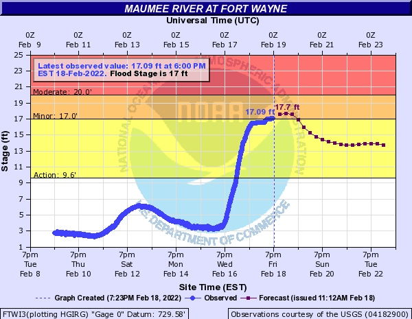
Maumee River at Fort Wayne affecting Allen IN and Paulding Counties.
Saint Joseph River Ohio below Montpelier affecting Williams County.
Saint Joseph River Ohio near Newville affecting Allen IN, De Kalb and Defiance Counties.
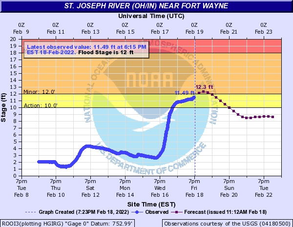
Saint Joseph River Ohio near St. Joe River Ft. Wayne affecting Allen IN County.
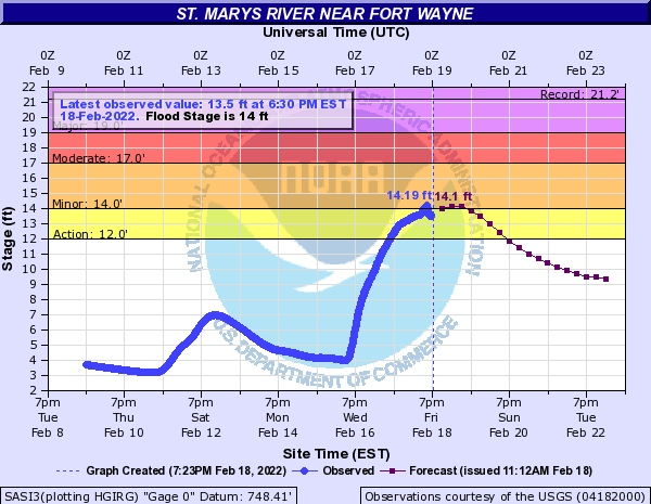
Saint Marys River at St. Mary`s River near Fort Wayne affecting Allen IN County.
Tiffin River at Stryker affecting Fulton OH, Williams and Defiance Counties.
Elkhart River at Goshen affecting Noble and Elkhart Counties.
Saint Joseph River Michigan at South Bend affecting Elkhart, Berrien and St. Joseph IN Counties.
North Branch Elkhart River at Cosperville affecting Noble County.
.These river rises will shift ice within the river and could lead to ice jams. This forecast is based on unobstructed flow and does not factor additional rises associated with ice jams.
PRECAUTIONARY/PREPAREDNESS ACTIONS…
Turn around, don`t drown when encountering flooded roads. Most flood deaths occur in vehicles.
Please report observed flooding to local emergency services or law enforcement and request they pass this information to the National Weather Service when you can do so safely.
Detailed river forecasts and additional information can be found at www.weather.gov/iwx under Rivers and Lakes.
This statement will be updated within the next 12 to 24 hours.
Jump to the details:
INC003-OHC125-191700-
/O.CON.KIWX.FL.W.0009.000000T0000Z-220220T2308Z/
/FTWI3.1.ER.220218T2040Z.220219T1200Z.220219T2308Z.NO/
550 PM EST Fri Feb 18 2022…FLOOD WARNING REMAINS IN EFFECT UNTIL SUNDAY EVENING…
* WHAT…Minor flooding is occurring and minor flooding is forecast.
* WHERE…Maumee River at Fort Wayne.
* WHEN…Until Sunday evening.
* IMPACTS…At 19.0 feet, The city of Fort Wayne launches 24-hour flood fight.
* ADDITIONAL DETAILS…
- At 5:00 PM EST Friday the stage was 17.1 feet.
- Recent Activity…The maximum river stage in the 24 hours ending at 5:00 PM EST Friday was 17.1 feet.
- Forecast…The river will rise to 17.7 feet tomorrow morning. It will then fall below flood stage tomorrow evening to 13.7 feet and begin rising again early Tuesday morning. It will rise to 13.9 feet early Wednesday morning. It will then fall again and remain below flood stage.
- Flood stage is 17.0 feet.
- https://www.weather.gov/safety/flood
INC003-191700-
/O.CON.KIWX.FL.W.0013.000000T0000Z-220220T2200Z/
/ROOI3.1.ER.220219T0400Z.220219T1200Z.220219T2200Z.NO/
550 PM EST Fri Feb 18 2022…FLOOD WARNING REMAINS IN EFFECT UNTIL SUNDAY AFTERNOON…
* WHAT…Minor flooding is forecast.
* WHERE…Saint Joseph River Ohio near St. Joe River Ft. Wayne.
* WHEN…Until Sunday afternoon.
* IMPACTS…At 12.0 feet, Lowland and farmland flooding near the river begins.
* ADDITIONAL DETAILS…
- At 5:15 PM EST Friday the stage was 11.4 feet.
- Forecast…The river will rise above flood stage late this evening to 12.3 feet tomorrow morning. It will then fall below flood stage tomorrow afternoon to 8.5 feet and begin rising again early Tuesday morning. It will rise to 8.7 feet early Wednesday morning. It will then fall again and remain below flood stage.
- Flood stage is 12.0 feet.
- https://www.weather.gov/safety/flood

INC003-191700-
/O.CON.KIWX.FL.W.0015.000000T0000Z-220220T2000Z/
/SASI3.1.ER.220218T1954Z.220218T2030Z.220219T2000Z.NO/
550 PM EST Fri Feb 18 2022…FLOOD WARNING REMAINS IN EFFECT UNTIL SUNDAY AFTERNOON…
* WHAT…Minor flooding is forecast.
* WHERE…Saint Marys River at St. Mary`s River near Fort Wayne.
* WHEN…Until Sunday afternoon.
* IMPACTS…At 15.0 feet, Flooding occurs on the lowest unprotected
city streets, park drives and county roads.* ADDITIONAL DETAILS…
– At 4:30 PM EST Friday the stage was 13.7 feet.
– Forecast…The river is expected to rise above flood stage
just after midnight tonight to a crest of 14.1 feet tomorrow
morning. It will then fall below flood stage tomorrow
afternoon.
– Flood stage is 14.0 feet.
– http://www.weather.gov/safety/flood
The latest National Weather Service weather story | Official National Weather Service Northern Indiana website
Related Images:


