
The updated Excessive Heat Warning from the National Weather Service, or download the Situation Report:
URGENT – WEATHER MESSAGE
National Weather Service Northern Indiana
328 AM EDT Sun Jul 1 2018INZ003>009-012>018-020-022>027-032>034-MIZ077>081-OHZ001-002-004-005-015-016-024-025-020000-/O.CON.KIWX.EH.W.0001.000000T0000Z-180702T0000Z/
La Porte-St. Joseph IN-Elkhart-Lagrange-Steuben-Noble-De Kalb- Starke-Pulaski-Marshall-Fulton IN-Kosciusko-Whitley-Allen IN-White-Cass IN-Miami-Wabash-Huntington-Wells-Adams-Grant-Blackford-Jay-Berrien-Cass MI-St. Joseph MI-Branch-Hillsdale-Williams-Fulton OH-Defiance-Henry-Paulding-Putnam-Van Wert-Allen OH
Including the cities of Michigan City, La Porte, South Bend, Mishawaka, New Carlisle, Walkerton, Elkhart, Goshen, Nappanee, Lagrange, Topeka, Shipshewana, Angola, Fremont, Kendallville, Ligonier, Albion, Auburn, Garrett, Knox, North Judson, Bass Lake, Winamac, Francesville, Medaryville, Plymouth, Bremen, Culver, Rochester, Akron, Warsaw, Winona Lake, Syracuse, Mentone, Columbia City, Tri-Lakes, South Whitley, Fort Wayne, New Haven, Monticello, Monon, Brookston, Logansport, Royal Center, Peru, Grissom AFB, Mexico, Wabash, North Manchester, Huntington,
Roanoke, Bluffton, Ossian, Decatur, Berne, Marion, Gas City, Upland, Hartford City, Montpelier, Portland, Dunkirk, Niles, Benton Harbor, St. Joseph, Fair Plain, Benton Heights, Buchanan, Paw Paw Lake, Dowagiac, Cassopolis, Marcellus, Sturgis, Three Rivers, White Pigeon, Mendon, Coldwater, Bronson, Hillsdale, Jonesville, Litchfield, Bryan, Edgerton, Wauseon, Archbold, Swanton, Delta, Defiance, Sherwood, Hicksville, Napoleon, Deshler, Liberty Center, Paulding, Antwerp, Payne, Ottawa, Leipsic, Columbus Grove, Continental, Pandora, Van Wert, Ohio City, Lima, and Spencerville328 AM EDT Sun Jul 1 2018 /228 AM CDT Sun Jul 1 2018/
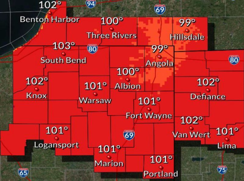
…EXCESSIVE HEAT WARNING REMAINS IN EFFECT UNTIL 8 PM EDT /7 PM CDT/ THIS EVENING…
HAZARDOUS WEATHER…
- Temperatures will reach into the lower 90s the afternoon. Heat indices will range from 100 to 105 degrees.
IMPACTS…
- The combination of hot temperatures and high humidity will lead to an increased risk of heat related stress and illness. The very young, the elderly, those without air conditioning, and those participating in strenuous outdoor activities will be the most susceptible. Failure to use caution could result in injury or even death.
- Car interiors can reach lethal temperatures in a matter of minutes.
PRECAUTIONARY/PREPAREDNESS ACTIONS…
Take extra precautions…if you work or spend time outside. When possible…reschedule strenuous activities to early morning or evening. Know the signs and symptoms of heat exhaustion and heat stroke. Wear light weight and loose fitting clothing when possible and drink plenty of water.
To reduce risk during outdoor work…the occupational safety and health administration recommends scheduling frequent rest breaks in shaded or air conditioned environments. Anyone overcome by heat should be moved to a cool and shaded location. Heat stroke is an emergency…call 9 1 1.
An Excessive Heat Warning means that a prolonged period of dangerously hot temperatures will occur. The combination of hot temperatures and high humidity will combine to create a dangerous situation in which heat illnesses are likely. Drink plenty of fluids…stay in an air-conditioned room…stay out of the sun…and check up on relatives and neighbors.
Young children and pets should never be left unattended in vehicles under any circumstances. This is especially true during warm or hot weather when car interiors can reach lethal temperatures in a matter of minutes.
Related Images:


