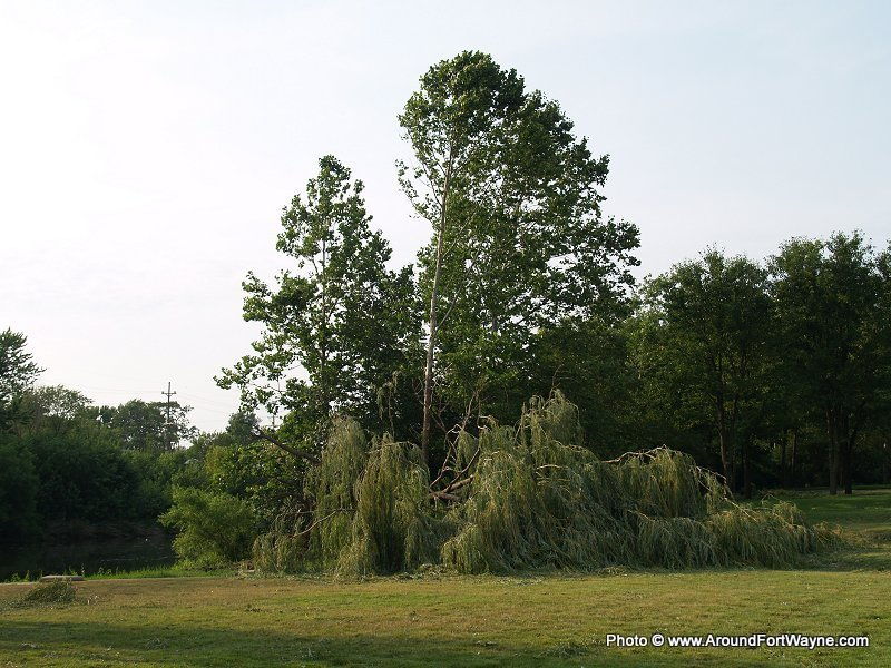
The National Weather Service has released an assessment of the historic Derecho that went through Fort Wayne last June 29th. The Derecho moved east to the coast leaving 4 million customers without power, 13 deaths and millions of dollars in damages.
According to the report, Fort Wayne had the highest official report of wind gusts at 91 mph. There was an Acu-rite anemometer 11 miles north-northwest of Cambridge, OH, measured an unofficial peak wind gust of 106 mph.
From the executive summary of the report:
Executive Summary
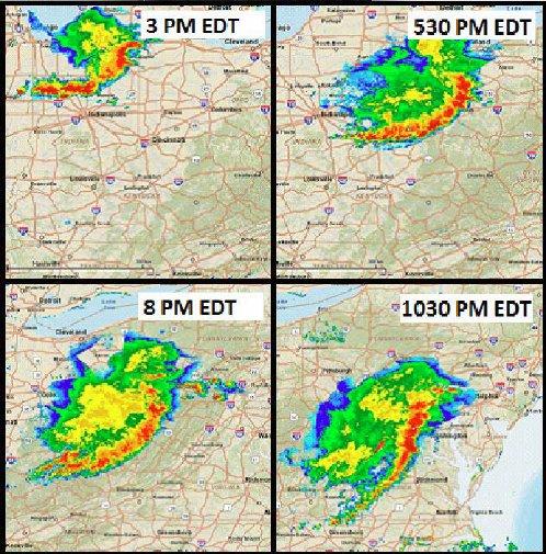
On June 29, 2012, a devastating line of thunderstorms known as a derecho (deh REY cho) moved east-southeast at 60 miles per hour (mph) from Indiana in the early afternoon to the Mid-Atlantic region around midnight. The states most significantly impacted were Indiana, Ohio, Kentucky, Pennsylvania, West Virginia, Maryland, Virginia, Delaware, New Jersey, and North Carolina, as well as Washington, D.C. Nearly every county impacted by this convective system suffered damages and power outages. Winds were commonly above 60 mph with numerous reports of winds exceeding 80 mph.
Some areas reported isolated pockets of winds greater than 100 mph. The storm resulted in 13 deaths, mainly a result of falling trees. One major impact from the derecho was widespread power outages. More than 4 million customers were without power, some for more than a week after the storms moved through. To make matters worse, the area affected was in the midst of a prolonged heat wave. There were 34 heat-related fatalities in areas without power because of the derecho.
The National Weather Service (NWS) formed a Service Assessment Team to evaluate performance during this event. Due to the widespread nature of this derecho, the team chose to visit the sites and review products and performance only at NWS Weather Forecast Offices (WFO) most impacted by the storms: WFOs Syracuse, IN (hereafter WFO Northern Indiana); Wilmington, OH; Pittsburgh, PA; Sterling, VA; Charleston, WV; and Blacksburg, VA. The team collected data from five other sites on the periphery of the damage path: WFOs Indianapolis, IN; Cleveland, OH; Jackson, KY; Mount Holly, NJ; and Wakefield, VA. A review of the products and services provided by the Storm Prediction Center (SPC) was also conducted along with numerous SPC staff interviews.
Unlike many major tornado outbreaks in the recent past, this event was not forecast well in advance. Warm-season derechos, in particular, are often difficult to forecast and frequently result from subtle, small-scale forcing mechanisms that are difficult to resolve more than 12-24 hours in advance. The National Centers for Environmental Prediction (NCEP) operational forecast models, such as the North American Mesoscale (NAM) and Global Forecast System (GFS), provided little assistance in forecasting this event more than 24 hours ahead of time. However, on the morning of June 29, some high-resolution, convection-allowing models began to provide clues that an intense line of thunderstorms could take the path that was later observed.
Because decision support activities were delayed until close to the event, key partners and decision makers had less time to prepare for the severe winds. In the Mid-Atlantic region, many forecasters thought the derecho would follow climatology and break up crossing the Appalachian Mountains. This past pattern for such events impacted the SPC’s outlooks, which did not extend the risk for severe thunderstorms eastward to the Mid-Atlantic coast until the afternoon of June 29. Therefore, WFO products and services, as well as preparedness efforts, were affected because the WFOs followed SPC guidance closely.
Despite the relatively short lead time for forecasting this event, the offices generally did an excellent job issuing warnings. Overall, lead times were greater than 30 minutes, especially on the eastern end of warning polygons. Most of the offices were issuing large warning polygons to cover the widespread nature of the event and the fast storm motion. All deaths occurred within severe thunderstorm warning polygon boundaries.
Three social scientists were included on this Service Assessment Team to help determine the societal impacts of this event and to suggest improvements to future services. The social scientists worked side by side with other team members participating in a wide range of briefings, interviews, and site visits. Consequently, many of the recommendations in this assessment report incorporate a social science perspective. A common theme that emerged from talking to emergency managers, media, and the public was that although they received the warnings, they were surprised by the intensity of the winds.
The team submitted 13 recommendations to address NWS performance, safety, and outreach programs. In addition, the team identified five best practices. Appendix B includes definitions of facts, findings, recommendations, and best practices followed by a complete listing of findings, recommendations, and best practices found within the main body of the report. Appendices C and D contain information concerning the deaths from the derecho and from heat. Appendix E provides a list of measured gusts greater than 57 mph recorded during this event.
The Summary:
A historic derecho impacted the Ohio Valley and Mid-Atlantic states on June 29, 2012. The event originated in northeast Illinois as a small cluster of thunderstorms. The derecho became organized over northeast Indiana during the afternoon and raced southeastward across Ohio and West Virginia at 60 mph. The derecho remained intact crossing the Appalachians, a climatological rarity, and caused widespread damage in the Washington, D.C., metropolitan area during the late evening. The derecho moved offshore shortly after midnight on June 30, 2012. In its wake, 13 people were killed and several million customers were left without power, many for several days. Tony Cavalier, Chief Meteorologist from WSAZ-TV Huntington-Charleston, WV, was quoted as saying, “The derecho was one of the top two impacting events in my 25 year career.”
This derecho was not forecast until the day of the event. Summertime derechos are often difficult to forecast because they respond to smaller-scale forcing mechanisms. Despite the extreme instability available for thunderstorms in the region affected by the derecho, the NCEP operational models were not indicating any disturbances that would help initiate and organize thunderstorms. This delayed the onset of decision support services and the use of enhanced wording in forecasts and hazardous weather outlooks.
On the day of the event, some of the CAMs that more closely simulate thunderstorms were developing an MCS over the area impacted. This allowed the SPC and WFOs to reflect the seriousness of the threat in their product suite. Much of the high-resolution, CAMs data are experimental and not available in the Day 2 forecast time period. Fully supported, ensemble, high-resolution model data extending further out in time are needed to improve the lead time in forecasting these extreme wind storms. Without these data, many of these derecho events will continue to have forecast lead times of 24 hours or less.
Numerous interviews with the public, media, and EMs revealed that despite accurate severe thunderstorm warnings and enhanced wording used by most of the WFOs, nearly everyone surveyed was surprised by the intensity of the winds during this event. NWS should move toward an impact-based severe thunderstorm warning so partners and the public receiving warnings have a better understanding of the storm’s severity.
The heat was a significant concern after this derecho, especially because of the widespread power outages. A heat wave that was building in the days leading up to the derecho continued for about a week after the event. More people died because of the heat in the days following the storm than from the derecho itself: 34 versus 13. Several WFOs lowered their heat advisory criteria in the areas hit hard by power outages by as much as 10 oF. NWS heat products should include an impact statement emphatically expressing the dangers of remaining in homes without air conditioning during prolonged heat waves.
Download the assessment
Related Images: